
![]() Version 10.5 of RelMo is now available for download. This release adds in an important new feature and fixes a couple of minor bugs.
Version 10.5 of RelMo is now available for download. This release adds in an important new feature and fixes a couple of minor bugs.
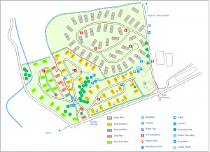
Introduced in this version is the ability to import an image directly into 2D views. You can then scale the image to the correct size using a variety of methods and then trace-over the important features of that image using the normal RelMo drawing tools to produce a simple plan view such as the example caravan park layout shown here
A new Background Image button is available on the Home tab of the ribbon bar to start the process. Click on this button and browse to the image you want to use. A copy of the image you select is made in your textures/2D Background folder so that RelMo can find it in the future. A new BackgroundImage object is created which contains the new image. Once created so you can use the Set Scale option from the ribbon bar to define a distance between any two points on the map. Click on the start and finish points and enter the correct distance in the dialog box which is displayed. The image is then resized to match your entered measurement. 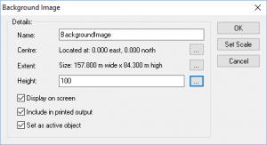
If you know for example the exact width and length of the image, you can use the Object Properties dialog to set that information instead.
Now that the background image is correctly sized, you can draw over the image to create lines showing the important features. BackgroundImage objects do not display any lines, points, triangles or panels other than the background image itself so don’t try and draw directly within the BackgroundImage object. You are likely to want to display and print only the plan you create rather than the background image itself. Instead create a separate object to contain your drawing points and lines. Then the original background image can either be hidden from view or deleted completely without affecting the plan you have created.
Please note that 2D images are flat and contain no height information so don’t expect a full 3D model with relief to be generated using this new technique! Any BackgroundImage will display in 3D, but it will be flat. Also, any plan you create from tracing over an image will only be to an approximate scale unless you use othorgraphically rectified images and are extremely careful about tracing over the features. Satellite and map images from Google, Bing etc. are not fully orthographic and some distortion is present, mainly to the outer edges. Maps generally do not necessarily show the correct width of roads either, so taking measurements from such a plan can only be approximate. However when you need a simple plan, this method can generate exactly what may be required.